Armchair Adventures - Frozen toes and Belgian waffles
Posted By Gravel Union
On 6 April 2020
Heading out on a gravel ride that locals think has never been completed in a single day before sounded like a bit of a challenge. When it also formed part of your honeymoon and you’ve told your new wife that it will be “fun” - that adds a bit of pressure too. Olly from the Gravel Union staff looks back to narrowly avoiding losing toes to frostbite and eating his own bodyweight in Belgian waffles on a gravel ride in the far north-west of Iceland
Text, images and video: Olly Townsend
Wouter stared us straight in the eyes. “You realise that no one has ever done that before” he said, looking carefully at us to see what kind of reaction we showed. He dug out a biro and scribbled his phone number on the slightly faded A4 copy of the route that he gave us. “If you get stuck, call me. But, there’s no mobile signal from here, to here” He drew two lines on the map, which seemed to indicate that for about 25% of the route, the bit furthest away from civilisation, we would be on our own. How hard could it be? It was only 70kms of riding, with 1000m of climbing, most of which was at the end. And one section that would be under water at high tide. Surely we would be fine?
Frozen toes and Belgian waffles is the story of cycling around the Svalvogar Circuit in the Westfjords region of Iceland on my honeymoon back in 2015. Iceland had suffered from higher than normal snowfall that spring, so part of the normal route was snowbound and inaccessible. This meant if we wanted to try and ride the circuit, we would have to ride 40% longer than the ‘standard’ route, undertake numerous crossings of snowmelt rivers and face a huge climb at the end of day. Wouter thought that no one had ever managed to ride the entire circuit in a day before. Surely this sounded like the perfect way to spend part of our honeymoon in Iceland?
Most sensible people wouldn’t choose to spend a day of their honeymoon wading through icy streams in the far north-west of Iceland, but then who said anything about being sensible. When we were researching our honeymoon trip we found a couple of grainy low-resolution images of 4x4 drivers attempting the tidal section of the route and our well-thumbed second-hand Iceland guide book mentioned that we could hire bikes from the Simbaholin café, so a plan was formed in our minds. Even now (five years later) a quick internet search results in pretty scant information about the route. There are some old blogs, a couple of single-paragraph Trip Advisor posts and not much else.
The circuit is little known outside of Iceland and is normally only undertaken by 4x4 drivers. It’s a circular route on gravelly/rocky four-wheel drive trails, which hugs the coastline. The track varies from running across a rocky beach (where it’s underwater at high tide), to running high up on a cliff. It’s incredibly remote, has no mobile signal for at least 25% and is inaccessible for all but the hardiest 4x4s. Perfect gravel biking territory then! Of course, back in 2015 gravel bikes were not the phenomena that they are now. They certainly weren’t available for hire, so we made do with what was available to us – a pair of hardtail mountain bikes.
Before we had arrived in Iceland I’d done as much route planning as I could. Using a combination of google maps and some low resolution web images that previous riders had posted, I put together a GPX file for us to follow. I’d read horror stories of weather changing on the route every two minutes, fog and poor visibility, so figured some digital guidance would be a big help. It was only when we arrived at the Simbaholin café and spoke to Wouter where he told us that the route I’d pre-planned wasn’t rideable due to heavy snow that we realised we would be relying at least partly on more old fashioned technology – a paper map, intuition and luck.
Luckily the route is actually pretty straight forward to follow – there aren’t that many junctions and for the majority of it you just have to remember to keep the ocean on your right hand side and the mountains on your left. From chatting with Wouter, the majority of the riders who tackle the route do the shorter 45km version and we would have gone for that had it not been snowbound. The longer route is perfectly achievable though – just make sure you’re self-sufficient in terms of spares/food/emergency clothing. We took our shoes and socks off for each of the many water crossings – a pair of lightweight hiking sandals would be a worthwhile addition to your pack if you can fit them in – it won’t make the water any warmer, but it will make it marginally more comfortable and safer.
If you look at the route profile you’ll see that 99% of the climbing comes in the last section of the route. The climb starts at the 53kms covered point. Before we started upwards, we stopped at the roadside and dug out every remaining bit of calories that we could find in our packs – we figured that a 10kms gravel climb which averages around 9% would need all the energy reserves that we had, and we were right. Luckily on the day we did it the ever-present Icelandic winds were kind to us. We certainly weren’t pushed up with a 100kph tailwind as we’d hoped, but we didn’t have a killer headwind either. The views on the climb make up for the pain somewhat – you get a beautiful and ever growing panorama to the south and then when you reach the summit you get stunning snow-capped fjords heading away from you to the north. With a bit of artistic licence, I was pretty sure we could see the coast of Greenland away off to our left, but that might have just been a hallucination from low blood sugar.
The final descent made the pain of the climb worthwhile – wide, perfectly graded gravel with stunning views. It’s over all too fast and there’s a slight sting in the tail with one final little kick before you descend back to Þingeyri. If you still had the energy and fancied more of a challenge at the end, there looked like there was a variety of amazing singletrack starting from the top of the final col – you might need a mountain bike rather than a gravel bike, but they looked super fun!
For anyone wanting to try this for themselves, we got our trail advice and hire bikes from the Simbaholin café in Þingeyri, which is also where we started/finished our loop. The Belgian/Danish owners were a font of knowledge about the route, fed us with perfect cappucino before we set off and double helpings of Belgian waffles when we got back. We can’t recommend them too highly.
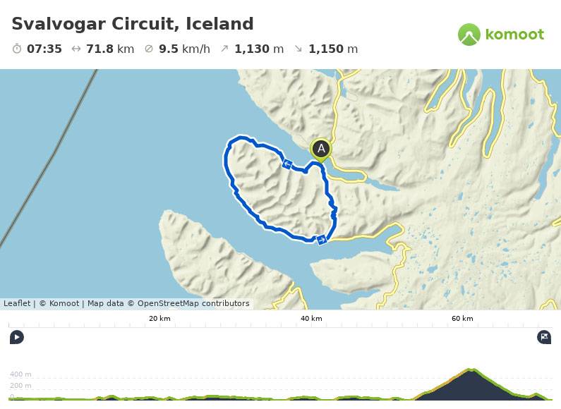
The entire route is 72kms and 1345m of climbing. You can find a GPX file and more details here